Tuesday, November 21, 2006

Old Tingri(老定日), Mt Shishapangma (希夏邦玛峰) (9/26-9/27)


We left Rongphu monastery around 10:40am. I gave up the original plan of going to base camp of Qomolangma, because I felt I had enough good shots of the mountain, and many books I read said the view from the base camp isn't that great, when compares to Rongphu.

Mr. Danzeng got some business for him (and me as well, since we share the money), three folks, 
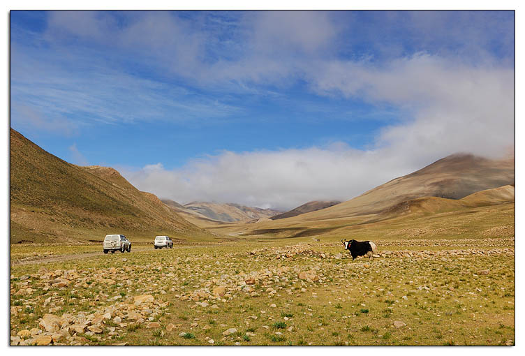
Carol, Richard & Peter, hitch-hiked our 4x4 to Old Tingri. They just came down from the Camp 1 of Qomolangma yesterday, and before that, they spent 7 days in a trail in Kangshung region (lies to the east of Mount Everest, which is considered by many the most spectacular side of the mountain). Danzeng over-charged them (Y200/person for a less than 80km ride is too much, me think), but not my business.

The route we took from Rongphu to Old Tingri is rather beautiful (well, much better than the one from New Tingri to Rongphu we took yesterday). Carol said this was one of the suggested trekking route on Lonely Planet's "Tibet" tour book. That brought some excitement to me -- yes, I hiked there, although I hiked on wheels! :P

Peter and Richard are camera geeks, but they are my "enemies" -- Canon users. ;*) We had a good time talking photography and the trekking routes in the car. Peter suggested me to get more exercises when I get back home, and next year plan for a hike in Kangshung. "You won't be disappointed!", Peter told me. Yes, I wish I can do that, but I know the chance rather very slim...

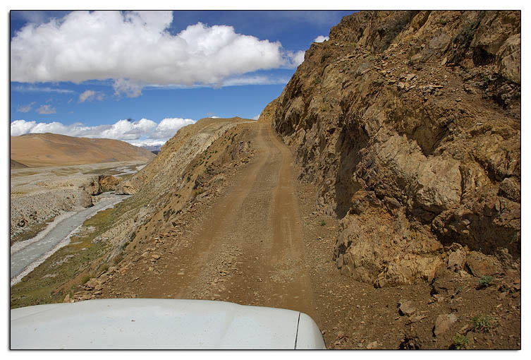
You can experience all sort of road conditions in this route.

One of the most dangerous spot
in this route.

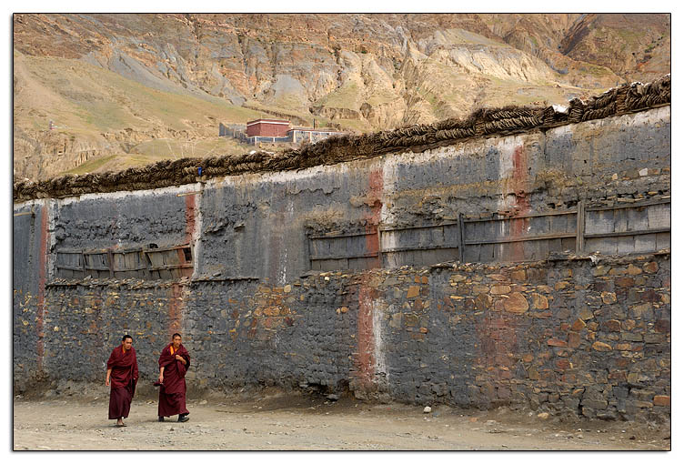
This is the typical Tibetan houses you can see in this
area -- the house has the special Sakya 3-colour strips,
the roof has layers of yak dung (locals burn dung for
fire), and at the corner, you see decoration of hay.
Though not 100% sure, I think this is probably
Mt Cho Oyu (卓奥友峰), 8,201m, the 6th highest
mountain in the world.


We arrived Old Tingri around 2:30pm. Nothing special in the town. We took a 2-hour break, had lunch in a Tibetan restaurant, said goodbye to Peter and the gang, then restarted my journey. Next destination is Porong village (波绒乡), a small town in the Mt Shishapangma area.

Right after we left the town Tingri, I found some very interesting photo opportunities at the roadside of the Sino-Nepal Friendship Hwy -- a vast grassland with Mt Qomolangma and Mt Cho Oyu stand in distant background. At the front, there are several large ponds. Water are crystal clear, and the reflection of those snow covered mountains
Mt Qomolangma (Everest) and Mt Cho Oyu.
Viewed from roadside, about 2km from Old Tingri.
Mt Cho Oyu, 8,201m
I can imagine sunset in here will be phenomenal

It was about a 2-hour drive from Tingri to Porong. About 5km before Porong town, Mt Shishapangma shows up from the left. The first impression of the mountain wasn't so good, compares to Mt Qomolangma, Shishapangma has nothing to be proud of.

According to my research, there is no guesthouse in Porong. We had to stay over night in local people's house. I thought that should be easy to deal with since my driver is a Tibetan. However, Mr. Danzeng did not look like he like that idea (well, maybe he has been living in Lhasa for too long, and already gets used to the lifestyle of having a clean bed to lay his body down ;P). On the way to the village, he stopped a truck that was coming out from the village, and asked the driver about the accommodation in Porong. That driver told us that there was no place to stay in the village, and about 3km from here, there is a checkpoint for the Shishapangma National Park. We can stay in the checkpoint. Obviously, Mr. Danzeng was delighted to hear this. So we moved on...

The checkpoint locates in the center of the vast Shishapangma plain (well, I really don't know what its name is). The office attaches to a courtyard that is served as the dormitory of tibetan road workers. The workers were kind enough to offer us a bed for tonight. All set, now I can concentrate on taking pictures.
Although the Mt Shishapangma looks very ordinary to me, but evening scenery here in Shishapangma plain is nothing short of phenomenal! I particularly like the vastness of the landscape. This is the very Tibet that lives in my imagination!

The Sound of Silence

What's your feeling about this picture? To me, it is 3 words: open, quiet & peaceful.

The vast golden plain, bordered with distant rolling hills, was illuminated by the colourful post-sunset twilight. A vision of peace, a sense of silence. A truck, carrying the "homebound" off-duty road workers, slowly entered the scene. The monotonous whine of the engine further intensified that feeling of "quiet".

The wide spaces and dazzling light harbour an unearthly intensity. It is like in another world...


After dinner, workers gathered together and started their daily gossip time. I had no idea what they were talking about, because they spoke only in Tibetan. However, by courtesy, I still sat in the room and "listened" to their conversation, although what I really did was casting my mind back to the beautiful scene I saw today. I just wished they could finish the gossip as soon as possible so that I could go to bed early. However, that did not happen -- they started drinking beers, bottle after bottle! (this surprised me, because during dinner, one worker told me that many workers in the room are not permanent workers. Being in temporary status, their wages were extremely low, about 20-25 yuans/day. Then how could they afford the beers, because beers in this place are not cheap?)

The long hours of sitting on
Mt Kangbochen
Mt Kangbochen, 7,281m
a low bed (only about one foot high!) last night did take a toll on me -- the next morning, after I got up, I found my back was extremely sore. So painfully that I even barely stretched my body! I was very concern about that because I 2 days from now, I supposed begin my kora to Mt Gang Rinpoche (Kailash), and I really want myself to be in a good shape when I do that!

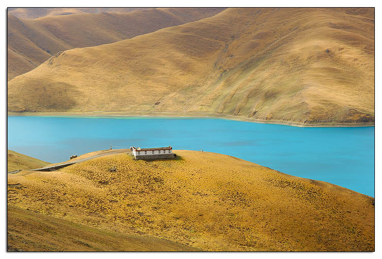
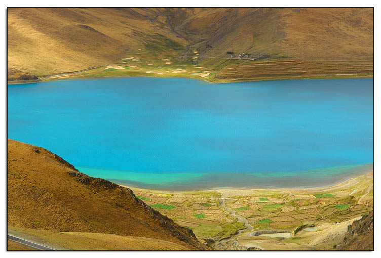
Shortly after left the Shishapangma checkpoint (a benefit of staying a night in the checkpoint is, the park guard considered we were friends to them so he waived our entrant fee to the park! :P), Mt Kangbochen (康波钦峰,又名岗彭庆) appears at the left side of the road. This mountain is much closer to us than is the Shishapangma, so it looks higher, although in fact it is about 800m shorter. Any way, the shape of Kangbochen is much more beautiful than that of the Shishapangma, at least when view from the highway.

An hour later, we arrived at the shore of lake Pekhu-tso (佩枯错). Although this lake is highly touted in many tour books, I did not feel it was any special -- a rather ordinary lake by Tibet's standard (there are way too many beautiful lakes in Tibet). The blue of the lake is very bright and brilliant though. Well, the lake may be beautiful, but the weather today might not justify its beauty -- it was too fine a day that not trace of clouds can be found on the sky! This render the scene very dull, at least when look from the viewfinder of my camera.

He was the first (I met a lot more later!) "crazy" guy I met in this trip -- a Germany cyclist who was at his 250-ish day of his "Cycling Around the World" journey.

There are many young Western took up the challenge and tested their limit in this barren place in western Tibet. Standing in front of them, I felt shameful and even guilty for taking a land cruiser trip, and worse, rent the 4x4 by myself alone!

Germany Cyclist


Visit my website at fototi.com for many photos of the Mt Shishapangma area.

Coming up: Sagar and Zhongba (ETA: 12/10/2006)

Sunday, November 12, 2006

Mt Qomolangma (ཇོ་མོ་གླང་མ) (9/25)


"Seeing is believing!" -- this is what I telling people this afternoon. It was truly a unbelievable experience today.

I woke up at 8am in the morning. Looked outside the window, it was raining!!! "Geez, why I had such bad luck", I told myself.

After breakfast (today's breakfast is Changba (糌巴), the 1st changba I ate in this trip), we left Shegar around 9am. At the Lulu Checkpoint, I asked the solider who examined my passport and permit about the likelihood of seeing Mt Qomolangma ("Qomolangma" is the Tibetan name (means "mother goddess of the world") of Mt Everest. It is also the name for the mount used in China . Since here it is Tibet, so I will use the Tibetan name, and forgot about silly nonsense name of "Everest") today. He replied "No way"!!! He also told me that the mount has been covered by clouds and mist for 3 days already. "Today", he said, "we have rain here, so it must be snowing right now in the mountain."


The rocks on the hills alongside the highway are very colorful -- brown, red and blue. And the rocks are heavily twisted, a strong evidence that tells why the Himalaya Range has so many top mountains.
After the checkpoint, it is a long winding drive up to Pang-la (加乌拉 -- 中英文差太远了!) pass. Not surprising, it was snowing here in mountain, even though is far away from the Mt Qomulangma! The road was a series of switchbacks going up the mountains. In the past two days, I found Mr. Danzeng was not a speeding driver, and sometimes I wished he could drive faster (Several days later, I found out the his Land Cruiser is not genuine Toyota 4500, I believed it was a re-make from a Toyota 62. Maybe that explains why it is slow). However, today, under this severe weather condition, he showed off his skill -- passed all other 4x4 we met on the switchbacks! Exciting, but scary.

Finally we reached the Pang-la pass. The altitude reading on my GPS was 5,180m. At Pang-la pass, on a fine day, one supposedly can see four 8000+m mounts of the Himalaya range: Makalu (玛卡鲁峰, 8,463m), Lhotse (洛子峰, 8,516m), Everest (珠峰, 8,848m) and Cho Oyu (卓奥友, 8,201m). However, this beautiful vista was ruined by the snow today. All I could see was a curtain in white!

We continued driving in snow for about two more hours, and arrived at Rongphu (绒布, 5,000m) around noon. I found a room in the guesthouse of Rongphu Monastery. People here don't know how to do math, I guess :P -- 40-yuan/bed for a 3-bed bedroom, but 20-yuan/bed for 4-bed, both rooms are of the same size! I took the 4-bed room, a no brainer.

The restaurant of the guesthouse was packed with travelers from all over the world. They all looked gloomy because of the weather. Of course, how many time one will have an opportunity to come to here visit the tallest mount in the world? And at that moment, it really looked like we all would lose this opportunity today.

Rongphu Monastery is claimed the highest monastery in the world (as least that is what my tour book says), but I doubt that -- at least the Dirapuk Monastery in Mt Kailash tops it, by 5,100m vs 5,020m, based on my GPS's reading.


Here is a photo of Rongphu Monastery taken at 1:45pm. You can see from the picture that the snow was indeed heavy


Another photo, taken inside the Rongphu Monastery at 2pm. A Tibetan woman was shoveling snow in courtyard.
After a short visit to the monastery, I went back to the guesthouse to take some rest, also to make plan for what I should do tomorrow -- stay here for another day hoping weather will turn around, or "stay the course", move on to the next destination. Around 4pm, I suddenly felt my room became brighter, then I looked out the window, wait, what is that -- oh my god, sunlight! Snow stopped, and there was sunshine (albeit weak) from the sky! I rushed out the door, celebrated this magic moment with other visitors.
Here is a photo to show how misty it was after the snow stopped.

I grabbed my camera bags and tripod, went up to the small hill next to the Rongphu monastery. Found a good spot, setup the tripod and the camera, then waited for the miracle to happen. Some locals here said even though the snow stopped, and sun came out, the chance to see Qomulangma is still slim, because the area was still very misty, and windless (w/o wind, no chance to blow away the mist). However, I just did not believe that -- somehow I felt the force was with me, and I would get whatever I hope today!
Rongphu Monastery.
At 5:38pm, Mt. Qomolangma
was still hiding behind the mist.
But as you can see in the photo,
there were more and more blue
in
the sky, clearly a good sign.
This is me, with the setup of
my photo gears. The tripod is
a Gitzo 1325, equipped with a
Bogen leveling base 3502, and a Markins Ballhead.
Hasselblad XPAN is the camera in this photo.

Everyone was waiting for
the miracle...
We all wanted to save this
precious moment forever

And the miracle did happen! About 5:45, Qomalangma finally took off the mask, showed her beautiful face to us lucky people. We exclaimed our excitement. This is simply unbelievable -- just 4 hours ago it still snowed like hell at here!

The air quality was particularly good after snow. This was the dream moment for any photographers. Click, click, click, kept on going, until the sun was set...


Rongphu is widely considered the best place
to shoot the north face of Mt Qomolangma,
because you can use this beautiful chorten as
a foreground element.
Sun was starting to set
Probably it wasn't the right season yet, the sunset
was not as spectacular as I hoped for.
I did some research after I got home, it looks like
colours in May to June are much better.
This was taken after the sun has completely set.
The scene was illuminated by twilight in nightfall.
Compares to its sunset, the sunrise in Mt Qomolangma
was even less attractive. Colours were weak (maybe
a different season (early spring) will be better),
but the real killer is the light -- nothing will look
good if it is in shadow!
Mount Qomolangma in morning
After taking this photo, we said farewell
to the mother goddess, continue to our
next destination -- (Old) Tingri.

To see more photos of Mt Qomolangma, visit the online photo gallery on my website fototi.com (will be launched by the end of November).

Oh, I can't let go an nasty issue, that is the restroom in Rongphu! Man, that was the ugliest, dirtiest and least comfortable toilet I ever seen (actually, days after I found another one that tops it). I don't wanna go into the detail on how the toilet look like, one word, ugly. I just felt amazing why such a beautiful place could have such a unfit thing here. I did not remember I saw such unmatched things in Nepal. Later I met a Tibetan tour guide in the kora road of Mt Kailash. I complained this matter to him, but he laid blame to Chinese government, claiming that the government did not allow locals to do renovation to the guesthouse, in the fear of making local rich. I took that as a grain of salt. I think the real problem is the mindset of the people here.

At last, that was something sad happened on me in here -- I lost my GPS (Garmin Geko 301) that I used on my Nikon D2X to record GPS data into pictures. I don't know where and when I lost it. I found out the GPS was not attached to the camera when I was taking the sunrise pictures in the morning. It is very sad -- now I wouldn't be able to geo-encode my photos when I do the Mt Kailash kora! :(


Next story: Mt Shishapangma
Previous story: Sakya Monastery

Sunday, November 05, 2006

Sakya Monastery and Shegar (New Tingri) (9/24)


Shortly after leave Shigatse, the scene outside the window changed quite a lot -- fewer and fewer green you could find, the colours were mostly dominated by yellow, brown and blue (sky). This reminded me that I am on the way to the "real Tibet", or the Tibet in my imagination. It was Sunday today, however, there were groups of little kids walking along the Sino-Nepal Friendship Highway, with school bags on their back. The driver told me they were going to their schools in Sakya town, on foot! (geez, that is a long ways to walk! The distance could be easily over 20km). Usually students stay in school for a week -- go home on Friday, and come back to schools on Sunday. When those kids saw our jeep, they waved their hands, hoping to get a lift. Mr. Danzeng never stopped to pick them up, and I really felt guilty about that. However, what can we do -- our jeep simply can't hold that many people.

Around noon we arrived Sakya (萨迦) town (altitude: 4336m), where the famous Sakya monastery locates. Sakyapa is one of the four main buddhism schools within Tibet (the other three are: Nyingma, Kagyu & Gelug). each with its own incomparable lineage of teachers and emphasis on particular practices. Sakya monastery is consisted of two monasteries: northern and southern monastery, on either side of the Trum-chu river. The northern monastery has been mostly destroyed, you can see its ruin sprawled across the hills. The newer (built about 200 years after the northern monastery) southern monastery is what people usually visit in these days.


The Main Assembly Hall of the Southern Monastery
The southern monastery was built like a fortress -- it has thick walls, with watchtowers on each of the corners. This should not come as a surprise -- during 1268 to 1354, Sakya was the capital of Tibet, and this monastery was the central power that ruled the entire Tibet! This was the first religious government with a lama as head of state. It set an important precedence for Tibetan government. This is why Sakyapa is also called "Flower Sect(花教)" -- buildings are painted in ash gray with white and red vertical stripes. The colouring is widely thought to symbolise the 3 important bodhisattvas (菩萨) -- red for Jampelyang(文殊), white for Chenresig(观音), and grey for Chanadorje(金刚手). This colour pattern becomes a symbol for the Skaya authority. Whenever you see houses with this colours, you know the owner is a practicer of Sakyapa order.

Sakya monastery is a pleasant place to visit. The monks over there are extremely friendly. Unlike other monasteries in Tibet, monks here LIKE being photographed! There are a group of young monks, when they saw me, with my (impressive) camera hanging on my neck, they rushed to me ask for taking photos of them. Here is the youngest one among them, putting his dinning bowl on his head. Well, I think this manner is sort of blasphemous for a religious man!

We left Sakya around 3:30pm, continue the way to the next destination: Shegar (协格尔,新定日). The weather wasn't looking good after Lhatse(拉孜) -- in Sakya, I could still manage to find some sunshine and blue sky, but here the sky turned gray and overcast. I am very concerned about the weather in Mt Everest tomorrow!

Due to some road-work, our jeep (and many others) had to stop and waited for about two hours near Katso-la (加错拉) pass, at altitude of 5000+m. Not fun!
We arrived Shegar after 7pm. This is a small town with nothing really interesting.

Next Story: Mt Qomolangma (Mt Everest).
Previous Story: Shigatse

Thursday, October 26, 2006

Shigatse (日喀則) (9/23)

After a rocky day of negotiation to settle down the issues with travel agency on my land cruiser rental to Ngari, I finally began my "long march" today, by myself (and the driver). Joseph dropped off the trip due to the AMS in Lake Nam-tso.

Weather of today wasn't good, an overcast day. I was very concerned about my luck in Mt Everest and the entire trip -- I wished the bad luck I had last year in Yunnan province won't happen again this time. The driver, Mr. DanZeng (丹增曲扎), seemed little worry. He said Mt Everest area is high enough that the cloud won't go there. I hope so.

The trip today seemed boring, oh well, maybe it is b/c I've visited all these places last time when I was in Tibet. The Lake Yamdrok-tso (羊卓雍错) is boring too, when compares to Nam-tso, esp. under an overcast day.


We arrived Shigatse very early, around 4pm. The most interesting story of today is the hotel where Mr. Danzeng took me to was the same guesshouse I stayed 15 years ago in Shigatse!!! The guesshouse is called "Danzeng Guesshouse" (旦增旅店), a small private owned hotel. Of course, the facilities are much better than last time I was here. It looks almost all guesses tonight in this hotel were foreigners, I guess it must be on some tour books (I should check the Lonely Planet book :P) and is famous among foreigners, just like the Yak Hotel (亚宾馆) and Banak Shol(八朗学旅馆) in Lhasa. The driver said because I am a "foreigner" :P, so he took me here. Good choice!

We spent some time in Tashilhunpo (扎什伦布寺) monastery. It seemed tomorrow here there would be some sort of festival (the 11th Panchen Lama was here as well), so today the monastery was doing some rehearsal. It attracted a large flock of people. So bad I won't have time to spend in here tomorrow, so I will miss it. (well, I actually don't have much interest in the tibetan dance though)

The weather wasn't good today, so I did not bother to take any photos of any architectures in the monastery. Maybe I should, in retrospect, especially when I fail to find a headline picture for this post!

I felt some headache today, worry about getting AMS (received an email from my brother, telling me that when he was in Tibet many many years ago, he got AMS several days after he left Nam-tso. His email really disturbed me), so I asked a cup of butter tea in the canteen of the hotel. Boy! This is the best ever butter tea I've ever drunk so far! So delicious, I think they must have use top-class butter to make it!

I remember I liked Shigatse very much last time when I visited here, and it was here where I witnessed a Tibetan sky-burial. However, this year I just did not feel the city interesting at all. Maybe it is the mood and purpose (of being in here) were different (last time Shigatse was one of my planned destination, but this year it was merely a "midway island" in my itinerary -- "我达达的马蹄是个美丽的错误/我是个过客/不是归人".

Next Story: Sakya and Shegar
Previous Story: Lake Nam-tso